Hiking Pico Duarte, Dominican Republic
Climbing Pico Duarte: where every step rises with the spirit of the Dominican mountains.
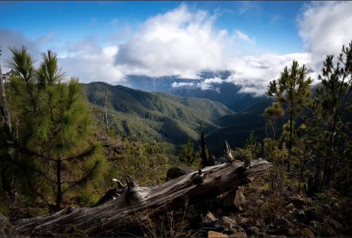
At first light, a golden haze spills over the peaks, illuminating a trail that weaves through whispering pine forests and across rushing mountain streams. The air is crisp, and each breath carries the scent of wet earth and wild orchids. Above the mist, the summit of Pico Duarte waits — not just as a destination, but as a rite of passage for those willing to embrace its challenge. Rising to 3,098 meters (10,164 feet), Pico Duarte is the highest point in the Caribbean. Tucked within the heart of the Cordillera Central range in the Dominican Republic, it commands not just altitude but awe. It’s a place where the landscape shifts from dense tropical forests to alpine vegetation, offering an unexpected variety of ecosystems along the way. What makes the journey to Pico Duarte so special isn’t just the physical ascent. It’s the rich biodiversity, from rare birds to vibrant flora. It’s the raw beauty of untouched wilderness and the quiet moments of connection with nature. It’s the physical challenge that rewards with sweeping vistas and the cultural pride embedded in reaching a peak named for one of the Dominican Republic’s founding fathers. Hiking Pico Duarte is more than a trek, it’s a soul-stirring adventure through one of the Caribbean’s most majestic landscapes.
Getting There
Reaching Pico Duarte begins with a flight into the Dominican Republic, followed by ground travel to one of the base towns near the trailheads. Here’s how to plan your route:- International Arrival:
- The two main international airports are:
- Las Américas International Airport (SDQ) in Santo Domingo.
- Cibao International Airport (STI) in Santiago de los Caballeros.
- Both airports are well-connected with flights from North America, Europe, and other parts of the Caribbean.
- Reaching the Base Towns:
- Most hikers begin their trek from:
- Jarabacoa (for the La Ciénaga route).
- San Juan de la Maguana (for the San Juan route).
- Travel options include:
- Car rental: Ideal for flexibility and exploring nearby areas.
- Public transport: Guaguas (local minibuses) run between major cities and towns, but can be slow and crowded.
- Private transfer or taxi: Faster and more comfortable, especially if arranged through a tour company.
- Tour Operators and Guides:
- Hiring a certified guide is mandatory for hiking Pico Duarte, as required by Armando Bermúdez National Park regulations.
Recommended tour operators are based in Jarabacoa and Santiago, and often include:
- Mules for gear transport.
- Meals and camping equipment.
- National park permits.
- Transportation to the trailhead.
- Book your guide or tour in advance, especially during peak season (December to March).
- If flying into Santo Domingo, consider spending a night in Jarabacoa to acclimatize and enjoy the town’s charm.
- Confirm that your guide or tour agency is certified and experienced with the route you plan to hike.
- Check the weather forecast and pack accordingly for both warm days and cold nights in the mountains.
The Routes to the Summit
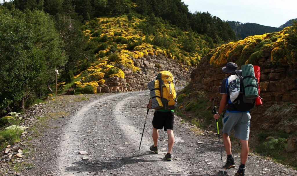
There are several ways to reach the summit of Pico Duarte, each offering a different experience of the mountain’s landscapes and challenges. While all routes require a guide, choosing the right trail depends on your fitness level, available time, and appetite for adventure.- La Ciénaga Route
- Duration: 2 to 3 days round-trip.
- Distance: Approximately 46 kilometers (round-trip).
- Difficulty: Moderate to challenging, depending on weather and fitness.
- Terrain: Well-maintained trail with a mix of forest paths, river crossings, and steep inclines.
- Weather Conditions: Cool and humid in the forested areas, with cold nights at higher elevations.
- Highlights:
- Most popular and accessible route
- Stops at well-maintained campsites like La Compartición.
- Great for first-timers or those short on time.
- San Juan de la Maguana Route
- Duration: 4 to 5 days round-trip.
- Distance: Around 75 kilometers (round-trip).
- Difficulty: More challenging due to distance and remoteness.
- Terrain: Remote mountain terrain, more rugged and less traveled.
- Weather Conditions: Variable, with colder temperatures and more exposure to wind at higher altitudes.
- Highlights:
- Offers solitude and untouched natural beauty.
- Fewer hikers and a deeper immersion in nature.
- Best for experienced trekkers or those seeking a less commercial experience.
- Mata Grande Route
- Duration: 3 to 4 days round-trip
- Distance: Roughly 60 kilometers (round-trip)
- Difficulty: Moderate, though less supported than La Ciénaga
- Terrain: Forest trails and moderate ascents, with some steeper sections near the summit
- Weather Conditions: Similar to the La Ciénaga route, with cooler temperatures at night
- Highlights:
- Lesser-known and less crowded.
- Offers a good balance between adventure and accessibility.
- A great option for hikers looking for something different.
Tips for Travelers:
- Choose your route based on your hiking experience, physical condition, and time available.
- All routes require at least basic physical preparation due to elevation gain and long hiking days.
- Expect sudden weather changes—rain gear and warm clothing are essential.
- Mules are available on all routes to carry supplies; confirm with your tour operator in advance.
- Acclimatize if possible. Spending a day or two in Jarabacoa or Santiago can help your body adjust to the elevation.
What to Expect on the Trail?
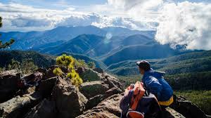
Hiking to Pico Duarte is more than a physical challenge—it’s an immersive experience in one of the Caribbean’s most diverse mountain ecosystems. Along the way, hikers will encounter a mix of campsites, natural scenery, and unforgettable wildlife. The most commonly used campsites are La Compartición and Valle del Tetero. La Compartición is the final base camp before the summit on the La Ciénaga route, offering basic facilities including wooden shelters, a cooking area, and tent space. Valle del Tetero, located on longer routes such as the San Juan de la Maguana trail, is known for its wide open meadows and tranquil setting, making it an ideal rest stop for multi-day treks. Both campsites are managed by park rangers and are relatively clean, though travelers should bring their own sleeping gear and be prepared for cold nighttime temperatures. Natural features along the trail are striking and ever-changing. Hikers pass through rivers fed by mountain springs, dense pine forests unique to the region, and high-altitude grasslands. The landscape offers a beautiful contrast between the lush, humid lower elevations and the cooler, sparser terrain closer to the peak. Frequent cloud cover adds a mystical atmosphere, especially in the early morning. The region is also a haven for wildlife and endemic flora. Birdwatchers may spot the Hispaniolan trogon, one of the island’s rarest birds, while sharp-eyed hikers might notice orchids clinging to tree trunks or small bromeliads hidden among rocks. The higher elevations are home to unique alpine vegetation not found elsewhere in the Caribbean, making the trail a rewarding experience for nature lovers. Reaching the summit is the crowning moment of the hike. At the top stands a statue of Juan Pablo Duarte, a founding father of the Dominican Republic, marking the highest point in the Caribbean. On clear days, hikers are rewarded with sweeping views over the Cordillera Central mountain range, often stretching as far as the northern and southern coasts. The sense of achievement, paired with the stunning landscape, creates a moment many describe as both humbling and exhilarating.
Tips for travelers:
- Pack layers. Temperatures can drop below freezing at night, especially near the summit.
- Carry a headlamp or flashlight, as there is no electricity at campsites.
- Bring a reusable water bottle and purification tablets; natural water sources are abundant but should be treated before drinking.
- Take your time and pace yourself. The altitude and terrain can be demanding, particularly for those not used to high elevations.
- Respect wildlife and the natural environment by staying on marked trails and packing out all trash.
Practical Tips for Hikers
Proper preparation can make the difference between a difficult trek and a memorable adventure when hiking Pico Duarte. While the trail is accessible to most healthy individuals, the mountain’s elevation, weather, and terrain require thoughtful planning and gear. The best time to hike Pico Duarte is during the dry season, from December to March. During these months, the trail conditions are more stable, with less rain and better visibility. April and May can still offer decent conditions, but the risk of rain increases. Avoid the hurricane season (June to November), as heavy rains can make the trail slippery, cause river crossings to swell, and limit access to campsites. All hikers must obtain a permit to enter the Armando Bermúdez National Park. These are usually handled by your guide or tour operator, who will include the cost in your package. Independent travel without a certified guide is not permitted, as the park requires all hikers to be accompanied by an official for safety and conservation reasons. Packing the right gear is essential. Temperatures at the summit can fall close to freezing, so warm layers are a must, including thermal clothing, a fleece or insulated jacket, and a hat and gloves. Waterproof gear, such as a rain jacket and cover for your backpack, is important, even during the dry season. Sturdy hiking boots with ankle support are highly recommended due to uneven and rocky terrain. Other essentials include a headlamp, extra batteries, a reusable water bottle, purification tablets or filter, trail snacks (like nuts, dried fruit, and energy bars), and a compact first-aid kit. Many tour operators provide tents and sleeping bags, but always confirm beforehand. While Pico Duarte is not a technical climb, a moderate level of physical fitness is required. You’ll be hiking long distances, sometimes 6 to 8 hours a day, often on steep inclines. Begin training a few weeks before your trip with regular walks or hikes, focusing on uphill climbs and endurance. Carrying a loaded backpack on your training hikes will better prepare you for the trail. Altitude is another important consideration. At over 3,000 meters, some hikers may experience mild symptoms of altitude sickness, such as headaches, nausea, or fatigue. It helps to ascend gradually and stay well-hydrated. The La Ciénaga route, with its overnight stops, allows for more gradual acclimatization. Listen to your body and communicate with your guide if you’re feeling unwell.Examples for travelers:
- If you’re coming from a sea-level city like Miami, consider spending a day or two in Jarabacoa before the hike to help adjust.
- Hikers from higher-altitude cities such as Mexico City or Bogotá may adapt more quickly, but should still prepare for colder temperatures.
- Even fit travelers who run or go to the gym regularly may find hiking at elevation a unique challenge—don’t underestimate the effects of altitude and rough terrain.
Cultural and Environmental Significance
Pico Duarte is not only the highest mountain in the Caribbean, but also a deeply symbolic landmark in the Dominican Republic’s cultural and national identity. Its historical roots, patriotic connections, and ecological importance make it much more than a hiking destination. Historically, Pico Duarte has long been a prominent natural feature of the island. Though it was known to indigenous Taino communities and early European explorers, it wasn’t until the 20th century that the mountain was officially named and measured. Expeditions in the 1940s and 1950s brought greater attention to its elevation and significance, eventually leading to its recognition as the tallest point in the Caribbean. The mountain is named after Juan Pablo Duarte, one of the founding fathers of the Dominican Republic. Duarte was a key figure in the country’s independence movement from Haitian rule in the mid-1800s and is revered for his leadership and vision of a free and democratic nation. The statue at the summit of the mountain is a tribute to his legacy, and many Dominicans see reaching the peak as both a personal and patriotic achievement. For local hikers, it is a pilgrimage that connects them to the roots of their national identity. Equally important is the mountain’s ecological role. Pico Duarte lies within the boundaries of the José Armando Bermúdez and José del Carmen Ramírez National Parks, areas created to protect the region’s unique high-altitude ecosystems. These mountains are home to endemic species, including the Hispaniolan pine, the rare solenodon (a nocturnal mammal), and several bird species found nowhere else on Earth. The cloud forests, alpine grasslands, and river systems that stem from this region are vital to the island’s biodiversity and water resources. Conservation efforts are ongoing and increasingly necessary. Over the years, the growing popularity of hiking has led to concerns about erosion, waste, and habitat disruption. Park rangers and local organizations work together to manage trail use, enforce guide requirements, and educate visitors about environmental stewardship. Responsible tourism is essential to preserving the beauty and integrity of Pico Duarte. Hikers are encouraged to minimize their impact by staying on marked trails, avoiding single-use plastics, and packing out all trash. Tour operators often brief visitors on best practices before the hike and work closely with the park to ensure that tourism supports, rather than threatens, the local ecosystem.Examples for travelers:
- Bring a reusable water bottle and avoid bringing disposable packaging. Refill stations are often available at campsites.
- Ask your guide about the flora and fauna you encounter. Learning about the environment makes the hike more meaningful and fosters a deeper appreciation for conservation.
- Choose tour companies that support local communities and conservation projects. Many reinvest a portion of their profits into trail maintenance or environmental education.
Personal Reflection or Quote Box
“I never imagined the Caribbean could be so cold,” laughed Carla, a traveler from Spain, wrapped in a wool hat and gloves as she sipped hot tea at La Compartición camp. “But that sunrise at the summit? Worth every chilly night and sore muscle. Standing there, above the clouds, I felt something shift inside me. It wasn’t just a hike, it was a moment I’ll carry forever.” Miguel, a seasoned guide from Jarabacoa, has led more than 100 hikes to the summit. “This mountain is part of who we are,” he explains. “It teaches patience, respect for nature, and reminds us that our land is full of wonders. For locals, it’s a source of pride. For visitors, it’s a challenge with a reward that’s not just a view, but a connection.” Hiking Pico Duarte is more than a trek to the Caribbean’s highest point. It’s a journey through history, nature, and personal resilience. From the first steps under the shade of pine forests to the final push toward the summit where wind and silence meet, each part of the trail invites reflection and growth. For those willing to take on the challenge, the rewards go beyond the panoramic views. You gain a deeper appreciation for the Dominican Republic’s cultural roots and its environmental richness. You test your limits and return stronger, not just in body, but in spirit. So pack your gear, lace up your boots, and take the path to Pico Duarte. It’s a trail that promises not only a summit, but a story you’ll tell for years to come.Pico Duarte Hike: Quick Facts
Everything you need at a glance before planning the climb:
| Detail | Info |
|---|---|
| Elevation | ~3,098 m — the highest peak in the Caribbean |
| Main trailhead | La Ciénaga de Manabao (near Jarabacoa) |
| Round-trip distance | ~46 km |
| Typical duration | 2–3 days |
| Guide & mules | Mandatory — arranged at the La Ciénaga park office |
| Park | Armando Bermúdez National Park |
| Best season | Dry season, roughly November–April |
Hiking Pico Duarte: FAQ
How hard is the Pico Duarte hike?
It’s challenging but non-technical — no climbing skills or ropes are needed. The difficulty is the distance and altitude over 2–3 days (about 46 km round trip). Reasonable fitness and a willingness to camp are the main requirements.
Do you need a guide for Pico Duarte?
Yes. A licensed guide and mules are mandatory and are arranged at the national park office in La Ciénaga. The mules carry gear and supplies, which makes the multi-day trek far more manageable.
When is the best time to climb Pico Duarte?
The dry season, roughly November to April, offers the clearest trails and views. It’s the high season for the climb; the off-season summer months are quieter but wetter. Nights near the summit are cold year-round, so pack warm layers. See our overview of the Dominican Republic’s mountains for the wider region.